I'm aware I've got three other walks I need to write up and, despite lockdown, time seems to be running away from me. I decided to concentrate on my latest walk while it's still fresh in my mind. I spent ages deciding where to go, drawing out several routes and then rejecting them because they didn't fulfill my ever growing list of criteria for an interesting walk: trigpoint, church with graveyard, benchmarks, a few contour lines, any other features of interest and new gridsquares. Hmmm. I'd better not add any more items to that checklist or nowhere will tick all the boxes!
I'm also finding that the more squares I'm covering, the more 'odd' squares are getting 'left out' and the only way to 'do' them is to devise a route covering squares I've already done, which for reasons already listed above, I am reluctant to do.
Enough of the preamble (forgive the pun), I hit upon Upper Largo. I had been told that the churchyard there was interesting, so set off on a mission early in the morning, parking by the church and wandering up there to have a look.
 |
| Upper Largo Church, NO4203 |
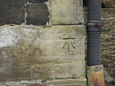
First things first, find the benchmark. Aha, one with a bolt.
 |
| Upper Largo Church 1GL Bolt benchmark -NO4203 |
There is an old cross behind bars in the churchyard, which I researched later. It is known as the Largo Stone and is thought to date from the 8th Century. It was found in 1839 in two parts, one of which was being used as a drain cover! For more information, visit the Largo Church History website.website
 |
| The Largo Stone, Upper Largo Kirk. NO4203 |
Having spent some time photographing a few gravestones, I headed out onto my walk proper, photographing a flush bracket on my walk east through the village.
 |
| Flush bracket on house, Main Street, Upper Largo. NO4203 |
I was not yet in new territory when I turned right towards Buckthorns and the shore. I had walked here with my brother a couple of years ago when we walked up Largo Law. I cast a cursory glance towards the farm as I passed in the hope I might spy the benchmark, but my GPS informed me it was still about 50 feet away - 50 feet that felt a little too much like trespassing, so I gave that one a miss.
 |
| Buckthorns farm building. NO4303 |
At least I was in a different gridsquare as I descended towards the bay, albeit not a new one.
As I approached Viewforth, I was drawn towards the fenceposts - not an unusual attraction for me as they are often adorned with lichen, especially the older fenceposts. These were not very old, but old enough to have some rather beautiful crustose lichens growing on them, which made for an attractive photograph.
 |
| Crustose lichens on fenceposts near Viewforth. NO4303 |
I had visited Viewforth before and written about it then, so I will refer you to that post.
 |
| Viewforth. NO4302 |
I might have visited Viewforth before, but I had somehow missed the benchmark which is on the ruin opposite.
 |
| Benchmark on ruin at Viewforth. NO4302 |
 |
| Other ruin at Viewforth.NO4302 |
I continued along the Fife Coast Path counting Curlews and Oystercatchers, but not seeing anything unusual, until I reached Carrick Villa. I was about to enter new territory.
 |
| Carrick Villa. NO4302 |
I turned right onto a track which led me past Broomhall and onto the A917. There was a lovely old horsemill at Broomhall, a relic of times past when horse power was commonly used to grind grain.
 |
| Horse Mill, Broomhall. NO4302 |
I still wasn't out of NO4302 but my next gridsquare was my first new one, and I was only in it for a short time.
 |
| Approaching the A917 near Drumeldrie. NO4402 |
I crossed the A917 and went up a track which led to Newburn School House. I read this interesting snippet about this former school:
About the middle of the 17th century, John Wood Esq, proprietor of the lands of Orkie, destined that property after his death for erecting a free grammar school in the parish of Drumclry, alias Newburn, and maintaining six poor scholars thereat. (Canmore)
 |
| Newburn Schoolhouse. NO4403 |
You can just see the school itself to the right of the building in the photo. Perhaps the large size of the house is accounted for by the fact it had to accommodate six poor scholars. There was no benchmark on this building, but there was a very faint, worn benchmark on the building just up the road from it, which took a little bit of detective work to spot!
 |
| Site of Drumeldrie benchmark. NO4403 |
 |
| Benchmark on above building. NO4403 |
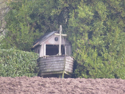
I was tempted to turn off left at the next opportunity, but chickened out as it looked slightly more private than the next turn off, which had an offputting 'Private. No Access.' type sign at the end of the road. Going by the theory that this only applies to vehicular traffic, I pressed on in full view of a dog walker. I'd hoped to stop here for my tea break but there was no opportunity. I took a photo of the impressive Coates House, the name of which features on several of the graves at the ruined Newburn Church, as I later discovered. The house dates from the latter half of the 18th Century. I was more interested in what appeared to be part of a wooden boat in the garden.
 |
| Coates House. NO4403 |
 |
| Boat at Coates House. NO4403 |
There was a bridge a little ahead of me and again I hoped to find somewhere secluded to enjoy my tea break, as well as look for the benchmark. I was deterred from both by the presence of a pheasant. "Big deal," I hear you say, which is what I would say too, until you saw this thing.
It would not leave me alone. It was obviously a tame pheasant and a rather handsome one at that. It mistook my hefty rucksack for a sack full of food, no doubt, and it was all I could do to keep it from nibbling my trousers! So that was the fair game part of my title. Part of the bridge was covered in sacking and, although I did not search the rest of the bridge thoroughly, I think the benchmark was underneath said sacking. It was one of only a few that I missed today.
 |
| Coates House Bridge. NO4403 |
I carried on past West Coates, where I managed to lose the pheasant and find another benchmark.
 |
| Farm building at West Coates. NO4404 |
 |
| West Coates benchmark. NO4404 |
I still hadn't found anywhere to have a break and I knew I wasn't going to find it along this road, though I was tempted to stop as there were some newborn lambs in the field opposite.
 |
| Lambs at West Coates. NO4404 |
A few cars passed me. I consulted the map. How long until I turned off onto a non-vehicular path? Aha! only another mile and then I turned onto a dead end track. Perfect. I found another two benchmarks within that mile. I was doing well today.
 |
| Benchmark on wall at West Coates. NO4404 |
 |
| Wall and tree stump at West Coates. NO4404 |
My heart sank when I saw that there was a caravan site where the dead end was. I was just considering my next course of action when I noticed an upside down sign, well, half a sign, attached to the five bar gate. It was labelled Flagstaff Hill. That's where I wanted to go, wasn't it? A quick check of the map confirmed it, so I forgot about the benchmark I was missing on the building at the caravan site, climbed the gate, went round the muddy corner and plonked on a pile of logs for a well-earned break. I usually like to avoid being overlooked, but I was getting tired and fed up and could not see another possible resting point for as far as the eye could see.
 |
| My teabreak stop with Flagstaff Hill in the background. NO4405 |
Wandering up Flagstaff Hill I wandered a little off the track into the next gridsquare; it seemed too good an opportunity to miss. I pointed the camera in the right direction and shot a picture of Cathrie, the only building in that gridsquare.
 |
| Cathrie. NO4505 |
Flagstaff Hill was the highest point of my walk today and it afforded excellent views of Largo Law, a hill I have photographed now from probably all directions.
 |
| Largo Law from Flagstaff Hill. NO4504 |
 |
| Leven and Kirkcaldy from Flagstaff Hill. NO4504 |
 |
| Masts at summit of Flagstaff Hill. NO4504 |
This was the part of the walk I was unsure of as there was no path marked on the map. I followed the lichen covered wall until I met the path with no difficulty at all. I felt quite elated. I looked to my right to see if I could make out the horseshoe shape of Horseshoe Wood, but I was facing it from the wrong direction. Perhaps I'd be able to make it out from below.
 |
| Rhizocarpon geographicum and Xanthoria parietina on wall on Flagstaff Hill. NO4504 |
 |
| Coming down Flagstaff Hill. NO4504 |
When I reached the minor road I was less than a quarter of a mile from Coates House; I had done a big semicircle. I turned left towards East Coates and then left again towards Charleton House along another road marked as Private. This one was a little more scary, but I continued undaunted, hoping to find somewhere now to eat my lunch. I passed some interesting sandstone gateposts with names inscribed upon them.
 |
| Gateposts, western entrance to Charleton House. NO4503 |
My next thought was to have lunch by the pond marked on the map, but, on passing another Private sign, I thought better of it, so wished good day to the Muscovy Duck silently on duty there (fair game) and walked on by.
 |
| Charleton House Pond with 'guard' Muscovy Duck. NO4503 |
It was only now that I consulted the map again. Where to have lunch? Then I saw it. A church marked in Old English Font. I had scoured the map earlier looking for such a thing. Howe had I missed it? No matter. I was just glad I had spotted it now and not when I to back to the house in a few hours' time. Newburn Church, here we come for lunch.
My spontaneous decision meant a bit of a detour and reminded me of one of the reasons I liked walking alone. I could make decisions like that without having to consult anyone. Feeling light and airy, I floated onto the gates at the southernmost entrance to Charleton House where two farmland geese were honking and creating a great fuss on the other side. My light feeling was beginning to sink, not just because of the geese, but because I could see a definite padlock on the gates and, as I approached the honking geese and the locked gate, I could see one of those numbered padlocks. A dog was barking loudly and the geese were making such a cacophony that I felt sure someone would come out and scold me any minute. No matter; I could see no way out of here. I briefly considered climbing the six, seven foot gate and thought better of it (for the second time that day). There were probably cameras everywhere. Just as despair began to flood my very being, I spotted another, normal sized gate with no geese guarding it, well, maybe it wasn't a gate, but it was a short wooden fence which I nipped over nonchalantly and then just had to shoo the geese away as I strode purposefully down the road towards the church.
I turned very briefly to photograph the benchmark on the lodge gateposts which the geese were still guarding.
 |
| Beware of the Geese (benchmark on bottom of gatepost). NO4503 |
I had no idea whether the church would still be extant (it was marked as a ruin on the map) and, if it was, whether, like so many others, it had been converted into a dwelling place. I could see a modern church but no sign of an older church, though the modern church looked further away than the one shown on the map. As I approached, I was delighted to find the ruined church with a non-locked gate. It was nestled comfortably between two bungalows, one of which had plenty of bird feeders. I would have my lunch somewhere secluded where I could see the bird feeders.
 |
| Newburn Church and churchyard. NO4503 |
I looked round the graveyard first and photographed a few graves, making a mental note to bring dad here to continue our research into interesting old gravestones. You can just see the Forth from here. Apparently the church was abandoned for worship in 1815 when a new church, to the designs of Alexander Leslie, was completed to its W. That later church has itself now fallen out of use, and was converted into a house in 1970. After abandonment for use for worship, the old church was put to use as a burial enclosure, and now contains a number of memorials. For more information about the history of this church see here.
Leaning against the church building with my lunch, I felt very satisfied and pleased with myself. I watched Tree Sparrows, Chaffinches, tits and a Great Spotted Woodpecker visit the bird feeders next door, lunching at the same time as me. Life doesn't get much better than this, I thought to myself.
 |
| Grave, Newburn Churchyard. NO4503 |
The only fly in the ointment now was the thought of walking back past the guard geese. I could delay no longer. As I approached said geese at the same time as a pick up truck appeared and slowed down at the gates. I was glad I was on the other side of the gates as the owner got out of the truck and scolded the geese, who should have been on the other side of the gate. Phew!
There was one more benchmark on another gatepost before I reached Siberia.
 |
| Gatepost bear Charleton with benchmark. NO4503 |
Siberia had been one of the attractions for today's walk. What was the background to such a name? I have not been able to find out yet. I crossed the A917 again and hoped the track I needed would be obvious; it was, but it was very muddy. That rarely bothers me; there are too many other things to be bothered about such as locked gates, pesky pheasants and scolding geese. I took the requisite photo of another ruin for NO4602, a square I was in ever so briefly and then sloshed my way across to Siberia.
 |
| Ruin near Siberia. NO4602 |
 |
| Siberia ruin. NO4502 |
It was a bit of a monotonous walk to the coast from here, past scrubby woodland and through arable fields. I was relieved to discover that the sandy land I had noted on the satellite map when I digitally 'reccied' this walk was not a huge sand/gravel pit, but a golf course. I had been a little worried about how I would circumnavigate it, but that was not a problem today as the golf course, along with everything else at the moment, was closed. I was back at Dumbarnie Links, a place I had visited last summer and had planned to return too. Perhaps not now though, as it was a bit dead, wildlifewise.
 |
| Part of Dumbarnie Links SWT Reserve. NO4501 |
 |
| Flooded Dumbarnie Links SWT Reserve near Lundin Links. NO4401 |
I couldn't remember if I'd taken photos of the squares last time I was here, so took some more anyway, not that there was much to see. I was in NO4401 ever so briefly and the lighting was poor. Another name intrigued me, Nannie's Knowe. The OS place names website has this record:
A small eminence of a conical
shape on the farm of Meikle Dun-
barnie. Its surface consists of rough
pasture,On its summit is a Trigl.
shape on the farm of Meikle Dun-
barnie. Its surface consists of rough
pasture,On its summit is a Trigl.
However, if Trigl stands for trigpoint, there is definitely not one there, and it doesn't look like there ever was, so that remains a mystery.
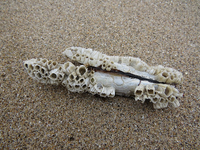
Weary now, I joined the relative throngs of other people enjoying the sunshine and Shell Bay. I would definitely come back here with Elaine for some serious beach combing. It was an ideal place for that pursuit, another of my favourites.
 |
| Barnacles on Razor Shell, Shell Bay. NO4402 |
 |
| Shells on Shell Bay. NO4402 |
 |
| Shell Bay looking west. NO4402 |
I was nearing the end of my walk now, but had three more benchmarks to find before I did. One was on a concrete post, which I thought unusual, but discovered this used to be a milepost on the East of Fife Railway, which ran between Leven and Anstruther with a station at Lower Largo which was operational between 1857 and 1965. I love finding out these snippets of information.
 |
| Old milepost from East of Fife Railway. NO4402 |
 |
| Benchmark on old milepost. NO4402 |
This was rather an attractive concrete post with lots of beautiful yellow Xanthoria parietina adorning it.
 |
| Xanthoria parietina on concrete post, Dumbarnie Links. NO4402 |
The next benchmark was on a house, which I zoomed into as my energy levels were too low to bother going down to it.
 |
| #12 The Temple, Lower Largo. NO4402 |
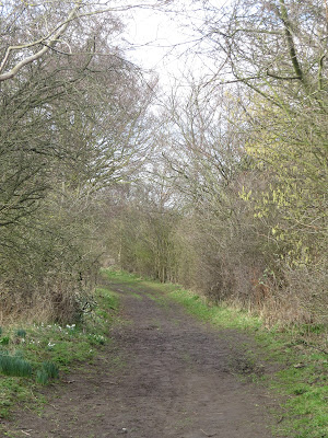
I followed a new (to me) path running parallel to the Largo Burn, leading north to Upper Largo.
 |
| Largo Den. NO4202 |
 |
| Catkins in Largo Den. NO4402 |
 |
| Eagle Gates between Lower and Upper Largo. NO4203 |
 |
| Benchmark next to Eagle Gates, NO4203 |
I had one more benchmark to go and I anticipated this to be on the Upper Largo Hotel, but again I was taken by surprise. It was on the wall opposite South Feus.
 |
| South Feus, Upper Largo. NO4203 |
 |
| Benchmark on wall opposite South Feus, Upper Largo. NO4203 |
The sun was now out and cast a glorious light on my final destination - the church where I had begun my walk 11 miles ago. It had been a walk full of surprises, frights and joys - and benchmarks!
 |
| Upper Largo Church. NO4203 |
Number of miles walked: 11.4
Number of new gridsquares: 12
Number of benchmarks: 13
Number of times nearly attacked: 2
Walk worth repeating: in part - definitely Shell Bay and Dumbarnie Links and Newburn Church, just a bit put off by Charleton House goose experience!
Highlights: number of benchmarks, Shell Bay, Newburn Church, lichen


No comments:
Post a Comment