It's not quite true to say I wish I'd not started this walk, but it is true to say it was one of the wettest walks I have ever done. Having said that, I have been on some very wet walks and each time it happens I wonder what made made me do it in the first place.
I do know what made me do it today. I was sick fed up of the weather thwarting all my gridsquare walking plans. I was sick fed up of looking out the window, checking forecasts obsessively and opting not to go out and then regretting it an hour later when the sun came out and proved the forecast wrong. I'd swithered half a dozen times that morning before looking out the window for the umpteenth time and deciding it had definitely stopped raining and then rushing to pack my lunch, grab binocs etc before it changed its mind again - or at least before I did!
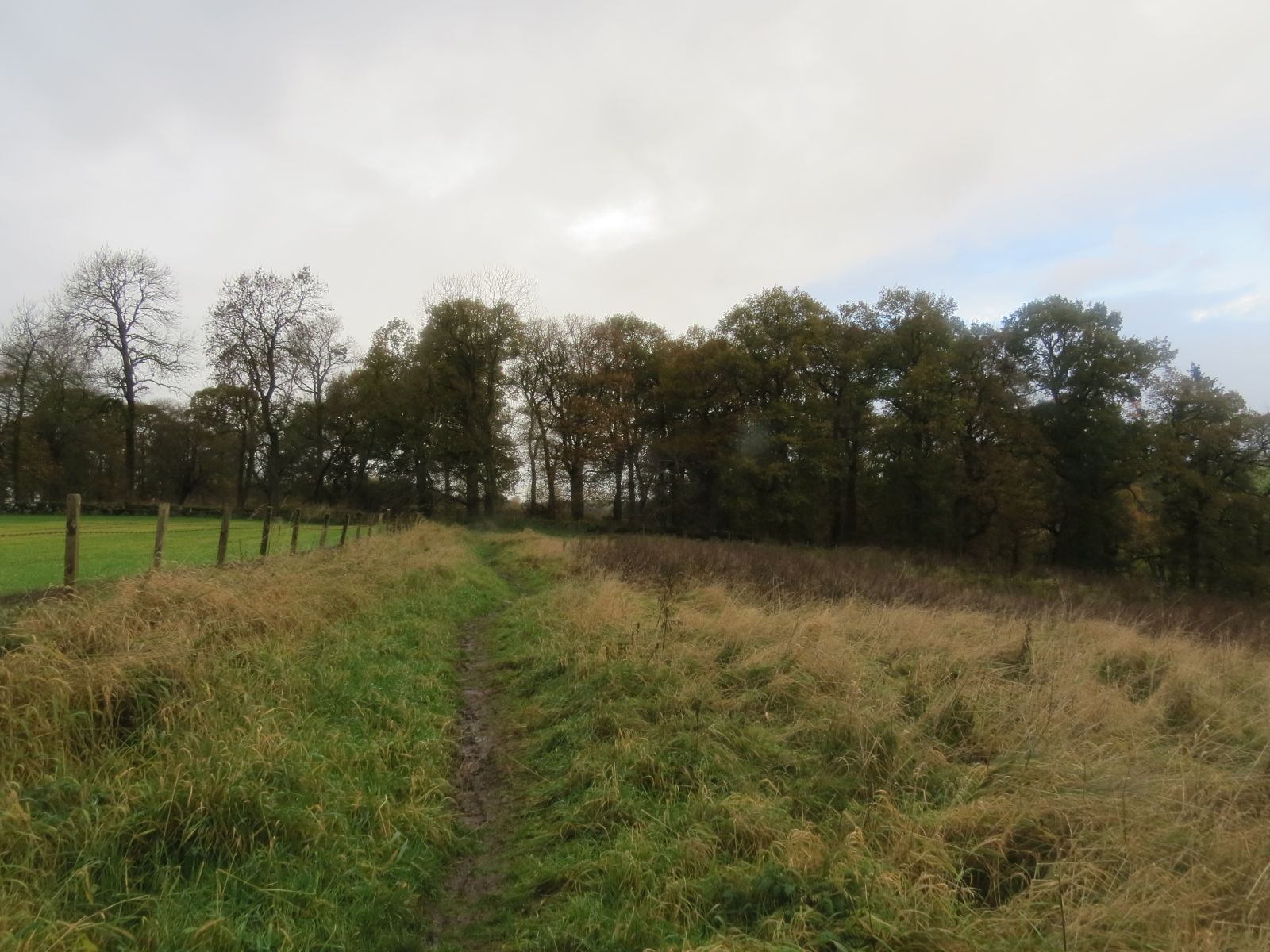
My choice of location for this walk was new to me, right at the northern edge of the Fife/Perthshire boundary and part of the county I had driven through many times, but had not stopped to explore. That was about to change. Relieved it was still dry, I pulled into the car park at Glen Vale where several others cars had parked before me, no doubt to climb to John Knox's pulpit. I donned my waterproof trousers and boots which meant there was no turning back and set off towards Glen Burn.
 |
Towards Glen Burn. NO1706
|
 |
| Glen Burn - NO1706 |
I admired the autumn colours and plethora of moss adorned walls as I ambled along, congratulating myself on having forced myself out of the house as it looked set to be a dry day. How wrong we can be!
 |
| Various mosses en route. |
I soon caught sight of a ruin ahead and got excited. I always get excited when I see a ruin. This one did look a rather dangerous place to wander into so I wasn't tempted. I could see bits of the structure dangling precariously down ready to fall, so gave it a wide berth and contented myself with imagining what it would have been like in days of yore.
 |
Easter Gospetry - NO1606
|
I did see my first of what I thought was going to be 20 benchmarks on the ruined gable on the right.
 |
Easter Gospetry benchmark - NO1606
|
Near the ruin I took some photos of a lichen. Since joining a new zoom group about lichens, I have come on leaps and bounds in my identification of lichens - in my dreams anyway, but think this one is Lecanora albescens.
 |
| Lecanora albescens |
My path continued northwards towards the A91 and I would soon be crossing into Perthshire.
 |
Looking back to Easter Gospetry - NO1607
|
 |
| Looking north to Perthshire - NO1607 |
The beautiful wall on my right as I walked towards Perthshire was adorned with many tempting lichens and I couldn't resist stopping to photograph a few. I'm glad I did now because my camera only came out by necessity for gridsquares hereafter for reasons which will become clear - even if the weather didn't!
 |
| Lichens on wall near Easter Gospetry - NO1607 |
I crossed the A91 and went straight into the grounds at Burnside. This is where I went 'wrong'. On the modern map (the one I should have used) I can see Yellowhill Road starts west of Burnside and there is no track east of the farm. There used to be though and that's the one I was so pleased was marked so well. I was so pleased with myself. It wasn't raining and I'd found the track very easily. This is when my obsession with maps comes in handy. I hadn't gone far along this well-marked path before I checked my map and discovered I wasn't on the track at all - it was a little further to the right. I retraced my steps but was unable to find the track, so decided maybe the well marked one I was on would eventually lead to where I wanted to go.
 |
River Eden from the 'wrong' track'. I needed to be on the other side of the river. NO1508
|
I continued walking along the track towards a wood, which is when I noticed a well marked on the map and thought maybe this track was heading there, which would be good because that was on the other side of the river.
 |
Entering the woodland south of the River Eden. NO1508
|
Once in the woods I discovered the path continued generally westwards, more or less following the Fife/Perthshire border as I had been doing. Desperate to head northwards, I descended towards the river in the hope of finding a crossing somewhere. From my elevated position I had seen that the river was in full flow, albeit quite narrow.
 |
River Eden. No1508
|
 |
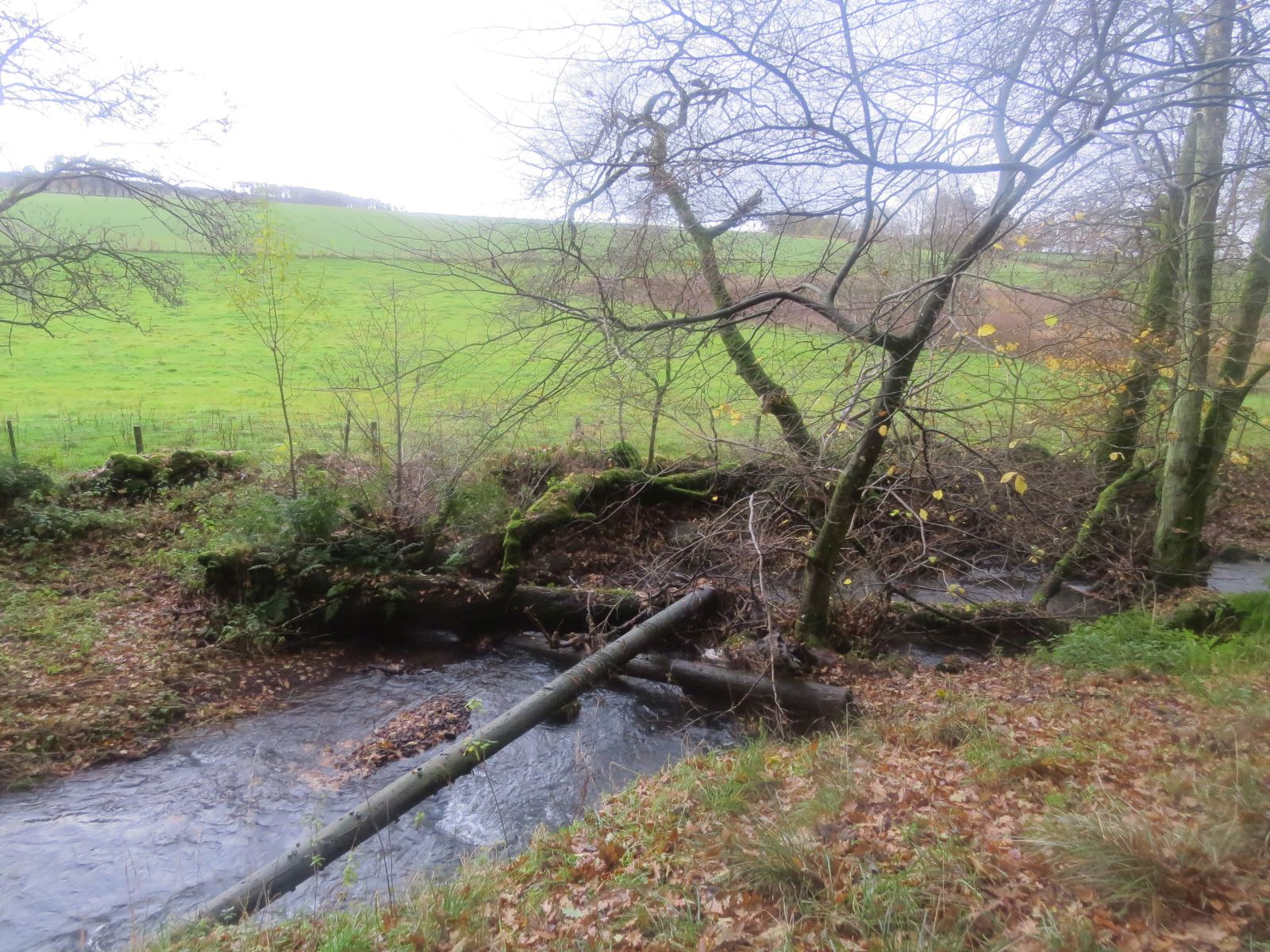
A potential crossing place over the River Eden. NO1508
|
I eyed up a few potential crossing places where trees had fallen across the river. This one looks easier than it did close up. I shunned it and attempted another one, thinking I could maybe shimmy across it, but first I needed to step over an obstructing branch and I didn't have the courage to stand up to do so. The photos do not give an impression of the speed or depth of the river or my level of cowardice!
I finally decided my best option would be to get one foot wet, step onto an island (like the one in the above photo), then get both feet wet stepping onto 'dry' land. I would need to do this quickly, but carefully as I didn't want my binoculars or camera to fall into the river.
Feeling quite proud of myself I stepped successfully onto 'dry' land at the same time as it began to rain. I was glad I'd already donned my waterproof trouser. Perhaps it would just be a shower I hoped as I surveyed the land and my map. Now where was that path?
The path was no longer there, but I managed to get out of the bog and ascend up to what turned out to be Yellowhill Road, the one I should have been on in the first place. Next time I will know. I say 'next time' because this was the only disaster of the walk, that and the weather of course, which could be avoided another time.
There was another very minor mishap when looking for Yellowhill Trigpoint. There were two options - approach from the south or approach from the north. I chose the wrong one. I fought my way through gorse and mud before deciding I'd have to turn back and try from the north. This was much simpler and I got to the trig in no time at all.
 |
| Yellowhill trig looking south towards the Lomonds, covered in mist. NO1509 |
The road made easy walking in the rain, which I realised was definitely NOT a shower and looked likely to last all day. Conscious that I would soon be crossing into Perthshire, but not entirely sure where the border was, I took a photo of the next gridsquare just in case. Turns out that one was in Perthshire, but I'll include it anyway.
 |
| Path to Burnside via Yellowhill. NO1410 |
I headed eastwards at this crossroads, eager to see Balcanquhal, which I had often driven past the turn off for, but never seen. I had read that Covenanting preaching had begun in Fife when John Blackadder, a famous Covenanting preacher, had visited Lady Balcanquhal and she had desired that he preach at her house. He had replied that services should not just be open to those who were interested. He "caused public advertisement to be made that all that were athirst might come without money and without price." "Let the world see," he said, "that you do not huddle up so profitable and honest a work or keep it to yourselves; as for my part I am not ashamed to avow it in the face of danger or death; I came not to call the righteous but sinners to repentance." (John Blackadder, the Covenanter by Hector MacPherson) This meeting was the first conventicle to be held in Fife. Of course, it is doubtful that the current Balcanquhal house is the one where John Blackadder preached, but the area is of interest nonetheless.
 |
Balanquhal House - NO1510 (Perthshire)
|
Feeling generally wet and miserable I crossed back into Fife and crossed the A912. As I was looking for the path to Corrinzion, my phone rang. I fumbled down my waterproof trousers to reach my pocket and retrieve my phone. It was dad but I didn't answer in time. I always get worried when dad phones as he so seldom does. I rang back, still trying to find my turn off. "I've got a cold," dad said in a roundabout way, "and I'm trying to book a COVID test." We spent a long while on the phone whilst I got wetter and more and more anxious. Meanwhile I had found my turn off and was trying to shelter beneath a large pine tree. Once satisfied that, as far as I could tell, it was just a cold and by the sound of it Tim had ordered a home test as there did not appear to be a test centre nearer his home than Glenrothes, I told dad I was getting cold and wet and needed to go. He sounded cheerful enough. "I'll phone later and see how you are," I promised. "No need," he replied. "Just phone if you get worse," I concluded. I hoped desperately that there would be no phone call.
Naturally this added to my misery, although I pushed it to the back of my mind and concentrated on the matter in hand. I was soaked and needed to move. Not before I took a blurry photograph of the gridsquare though.
 |
Corrinzion farm track - NO1610.
|
Reaching a T-junction, I turned right down Leden Urquhart road.
 |
| Leden Urquhart Road - NO1710 |
I find when damp and despondent that it is important to keep one's spirits 'dry'. That is partly why I have purpose to my walks, Whatever the weather it is my aim to get to the next gridsquare, the next benchmark, to see a new bird/flower/lichen whatever. It definitely helps. On this occasion, it was a benchmark, one of the few I saw today.
 |
| Leden Urquhart Road rivet benchmark - NO1710 |
It was on a gatepost and framed by moss and lichen. Who else had stopped to appreciate it? I wondered. Perhaps the farmer knows of its existence but otherwise I may be the only one. I recrossed the A912 at Upper Pitlochie. Next time I drove to dad's I would look out for the road I'd walked. I always find a certain amount of satisfaction in being able to smugly say, "That's the turn off I took when . . ." even if most of the time I am my only audience!
 |
| Turn off to Glentarkie (Off Road Driving Centre) and the road I walked down. NO1709 |
I plodded on southwards in the pouring rain, glad of my makeshift waterproof camera case cover (a carrier bag which fell off shortly after without me noticing and which I'm ashamed to say I did not go back to retrieve). Crossing the A91 again and then the River Eden (thankfully much less traumatically than my earlier traverse), I saw through the mist the only person I'd encountered all day - naturally with dogs on tow. I paused to peruse the map. The route I'd drawn now headed eastwards towards Gateside, but I was tempted to follow the track directly south, thus saving a good mile and a half of my journey. What about your girdsquares? I hear you ask. Don't think I hadn't considered that. Naturally I had, and I wouldn't be missing any out by doing this. But I couldn't afford to have to turn back if the track expired. It was too near the end of my walk and I was too wet and miserable. I should add that somewhere at some point I sat on a very wet stone and ate a very wet sandwich, but I can't remember where.
With discretion being the better part of valour I followed my dog walking companion along the River Eden through glorious mud to Gateside. I slithered and slided whilst she took a drier route. "You opted for the better route, I see," I called across to her as I struggled to stay upright in the squelchy, slippery mud bath.
I squinted through the blur in front of my eyes with the hope of seeing Kingfisher on the River, but no such luck.
 |
| Ruin near Bannaty Mill. NO1708 |
 |
| A foggit (moss covered) branch across the River Eden. NO1708 |
I emerged onto Station Road, turned right, crossed a railway bridge (where I saw another benchmark) and continued northwards. I was on my last leg now - in more ways than one!
 |
| Benchmark on bridge on Station Road - NO1808 |
 |
| Bridge on Station Road, Gateside. NO1808 |
I turned right at Wester Nether Urquhart and trudged along tarmac through my final gridsquare of the day, thinking that this would be where I'd have turned up had I risked taking the other track and also realising that I would have missed a square after all, but that I probably wouldn't have cared. Och well, I was wet anyway and it would be hard to get any wetter.
 |
| Turn off to Lappie Farm. NO1707 |
As is often the case on days such as this, the road seemed to stretch on forever, but I finally made it back to the carpark, which was surprisingly full. Poorly shod families were holding coats over each other as they dashed back to their cars. Generously I allowed them to get back in their car whilst I waited for their doors to close and began the long process of returning from my amphibious state to mammalian state once more.
Number of miles walked: 9.8
Number of new gridsquares: 11
Number of trigpoints: 1
Number of benchmarks: 3
Walk worth repeating: yes, without the crossing the river bit.
Highlights: views (if clear enough!), South Kinaldy, Covenanter interest, River Eden