I had started to drive through the village of Largoward every week on my way to orchestra rehearsals at St Andrews. I felt it was time to stop and explore so I devised a circular route starting from the village.
It took a while to find somewhere suitable to park, but I found a small car park off the main road just before exiting the village northwards and donned my walking attire. This always takes a little time. My brother hops out of the car and is immediately ready for the walk. I have a little, almost spiritual, routine which is fine when it's just me, but frustrating for others if they're standing waiting for me. The routine involves switching my GPS on and laying it on top of the car so it can receive a signal whilst I'm putting my boots on. Then I put my rucksack on and clip my camera to the caribiner, buckle my rucksack, put my binoculars round my neck and finally cow loop my GPS to a strap on the right hand side of my rucksack, place it in one of the side pockets, lock the car door, place the car key in the other side pocket and I'm ready for off! Phew! All in under five minutes - though I've never timed it.
Today's location was unambiguously within NO territory and my first photo was off the tiny church in Largoward.
 |
| Largoward Church. NO4607 |
There was no graveyard here, so I did not linger longer than necessary to take the photograph and then continued northwards to turn right at Cadger's Road towards North Cassingray.
 |
| Cadger's Road. NO4707 |
Just before entering NO4807 I turned left down an overgrown track that led to North Cassingray to take a photograph of NO4708. It was just too temptingly close to resist and, being at the beginning of my walk, I was still bursting with energy and enthusiasm - something that tends to wane after ten miles!
 |
| Lathones. NO4708 |
The village of Lathones lies within this gridsquare so I could photograph it quite easily from the track, and then retrace my steps back to Cadger's Road and my onward trail. My next turn off was also arguably gratuitous, but had as its lure Pepper Knowe trigpoint. The map showed a footpath to the trig, but when I approached I couldn't open the gate and I could see a man and his daughter in the house next to the footpath. Not wanting to climb over the gate in full view, I enquire about accessing the trigpoint and was assured it was fine to do so by climbing over the gate and probably also the one at the top of the hill.
A concrete path follows the fenceline up to the modest height of 212 and the muddy summit of Pepper Knowe.
 |
| Pepper Knowe trigpoint. NO4807 |
 |
| View north from Pepper Knowe. NO4807 |
I scanned through my binoculars to see if there was an obvious route down to North Baldutho which would save me having to retrace my steps, but I could not see one, so it was back through the mud and down to the road again. At least I'd get to do another gratuitous gridsquare this way. I walked only as far down the track to North Casingray as I needed to in order to enter NO4808 and take a photograph of the farm.
 |
| North Cassingray Farm. NO4808 |
As I continued eastwards, I was surprised to see a thin layer of snow on the road where the sun had not yet reached.
 |
| Snow on road to North Cassingray House. NO4807 |
The road ends at North Cassingray House and becomes a track, and an overgrown one at that. I doubted this was a well used path as I trudged my way over hummock and bog eastwards to Knights Ward (no apostrophe on map). I love finding this seldom used paths; absolutely revel in it. I can't really explain why, just the feeling that few have ventured here, the feeling of being away from it all, of forging my own path which is something I tend to do in life figuratively as well as literally. Sometimes of course, both figuratively and literally, I come across seemingly insurmountable obstacles and have to reconsider my options. That happened once or twice today, but has happened numerous times in a figurative sense in my life.
 |
| Footpath to Knights Ward. NO4807 |
The path became slightly less overgrown in the next gridsquare.
 |
| Foothpath to Knights Ward. NO4907 |
At a crossroads near North Baldutho, I managed to take a wrong turn. It looks so obvious on the map, but there are five ways in which one could go; I had come from one direction, so that left a choice of four, so you can see how I managed to make the mistake and didn't realise it until I'd done exactly 730 feet in the wrong direction and happened to look at my phone map (it's a good job I do this as frequently as I do) and realised my mistake. So, it was a case of back over hummock and bog and back through the gate I'd had difficulty opening and rethinking. It was pretty obvious then which route I had to take - the least obvious one!
At Knights Ward Wood I stopped for a break, sitting on a tree stump and brought out my trusty red flask for a cup of tea. I then dodged in and out of electric fences and avoided a herd of cows on my way to Knights Ward Farm and the minor road.
 |
| Approaching Knights Ward Farm. NO5007 |
 |
| Stuck in the mud at Knights Ward Farm. NO5007 |
I think I surprised the farmer as I emerged from the footpath as I can't imagine many people use it. He bade me good morning though, but didn't stop to chat. I'd like to have asked him about the old car stuck in the mud at his farm. Perhaps another time.
Once at the minor road, I turned right and walked to the former railway bridge where I found a benchmark.
 |
| Benchmark on bridge near Knights Ward. NO500707 |
 |
| Former railway bridge near Knights Ward. NO5007 |
I have since discovered that a short section of the East Fife Central Railway between Knightsward and Lochty was privately owned and run by farmer
John Cameron, who purchased a main line steam engine and operated it here between 1967 to 1992 with a steam museum at Lochty. For more information a photos of the line in use and shortly after its closure, see this Flickr site.
Gillingshill Reservoir soon came into view, straddled annoyingly across two gridsquares. I don't like it when this happens as, purist that I am, I like to know that the subject is slap bang unambiguously within one gridsquare. I'd thought of the loch as being a possible lunch spot, but was glad it was too early as there was nowhere to sit. I saw Tufted Duck at the other end of the loch though, which was a new addition to my day's bird list.
 |
| Gillingshill Reservoir. NO5106 |
Now for a little detective work - how to get up Kellie Law for my second trigpoint of the day. I passed one option, but there was no path marked on my map at that point, so I soldiered on, bravely pursuing a path which looked increasingly unlike to appear the closer I got. This was one of the few times in my experience when a path is shown on my old 2004 map that is not shown on the newer 2014 map, but I did not realise that at the time and was to suffer embarrassment as a result.
The old path to Kellie Law had been well and truly cut off and though there was only a deer fence between it and me, I knew I was not going to be able to scale that fence (though I once did on Islay). Instead I tiptoed stealthily through Gillingshill garden to a small gate and into an orchard where a man was busy tying up his trees. He was to be the second person I startled that day.
 |
| Gillingshill Lodge. NO5106 |
I walked up to him and apologised for intruding and possibly trespassing and asked if it were possible to ascend Kellie Law? He gave me directions back to where I'd come from and the double gate I'd deliberated not used as there was no path marked on my old map. I mentioned this to him and he replied that that must be a very old map I was using as that path had not existed for many years. I didn't think 16 years was that old really, not like the 1800s, but didn't argue the point. Instead I apologised once more, laying it on thickly when he asked how I'd got to where I was and I'd had to admit I'd wandered through a garden. "Best go back the way you came," he said.
I did and eventually found my way into the necessary field where Kellie Law lay temptingly before me. That would be my lunch spot.
 |
| Kellie Law. NO5106 |
Having got into the right field, it was a hop, a skip and a jump to the blowy summit where I sat unsheltered with my well-earned picnic and observed the world from my lofty height.
 |
| Looking west from Kellie Law. NO5106 |
 |
| Looking east from Kellie Law. Carnbee Reservoir in foreground. NO5106 |
 |
| Isle of May from Kellie Law. NO5106 |
The views from here were amazing in all directions, and it was an ideal day for being up here, albeit very cold and windy. I had the place to myself and suspect I often would have given the difficulty I'd found in getting up here. But it was too cold to linger long and I made the decision not to descend to Carnbee Church. When planning the walk I had included that as an optional extra if time and energy permitted. I had already made two diversions and so decided to leave Carnbee for another time. Besides, I like to have a reason for returning.
Back on level ground I retraced my steps as far as the turn off to South Baldutho. I passed a garden gate I'd not noticed on my outward trip. It made me chuckle.
 |
| Do not ask for directions. Greenside Cottage. NO5106 |
They must have had a number of travellers calling for that very reason! Fortunately I did not need to ask for directions; I'd already done that with the man in the orchard. I wandered gaily along, turning towards South Baldutho getting excited about the rivet I was soon to see!
 |
| Kellie Law and Gillingside Reservoir. NO5006 |
I saw nothing new on the choppy reservoir so turned my eyes to the ground in search of the rivet. There it was on the culvert! I say 'there it was' as if it was easy to see. Do not be fooled. I like to think I'm the first person to have seen this rivet in many a year. It was covered in moss and very faint and difficult to photograph, but I think you'll agree it's a beauty.
 |
| Culvert near South Baldutho. NO5006 |
 |
| Rivet (just right of white lichen blob) on culvert near South Baldutho. NO5006 |
I recovered from this excitement and continued westward to an unexpected quarry. This is not mentioned on the new version of the OS map either. It made a good subject for my photograph of this gridsquare though, particularly as I wouldn't be in it for very long.
 |
| Belliston Quarry. NO4906 |
Here I followed the path south and tried to find a way into NO5005, so temptingly close, but could not find an easy way in and I didn't feel like trespassing again! There was no-one around as I came to the entrance to the quarry at the minor road where I turned right and continued westwards for a third of a mile to Gibliston Cottages. Here I turned right again and walked towards Gibliston Farm where a friendly collie came out to see me.
 |
| Gibliston. NO4905 |
Beyond the farm I walked uphill towards Clachreid Ha' Wood, photographing Cunner Law on the way.where a ruin caught my eye. I'm always attracted to ruins.
 |
| Cunner Law from NO4905 |
 |
| Walking uphill to Clachreid Ha' Wood. NO4805 |
A ruin provided an attractive subject for this gridsquare. Apparently the ruin was actually once two small thatched cottages tenanted by agricultural labourers.
 |
| Ruin in Clachreid Ha' Wood. NO4805 |
 |
| Isle of May from Clachreid Ha' Wood. NO4805 |
I'm always glad to see the Isle of May when out walking. It feels like mum is waving to me. We went there for my 50th birthday so it remains a very special place.
At the top of the hill I paused for breath and realised a few diverted steps would lead me into another gridsquare. This is where you have the advantage of walking on your own; you don't have to ask anyone's permission to stride purposelessly off in a direction in which there seems to be no attraction.
 |
| Muir Plantation. NO4806 |
I was thankfully now on level ground and walking through woodland along a very puddly path.
 |
| Clachreid Ha' Wood. NO4805 |
 |
| Arboreal Wonder in Clachreid Ha' Wood. NO4805 |
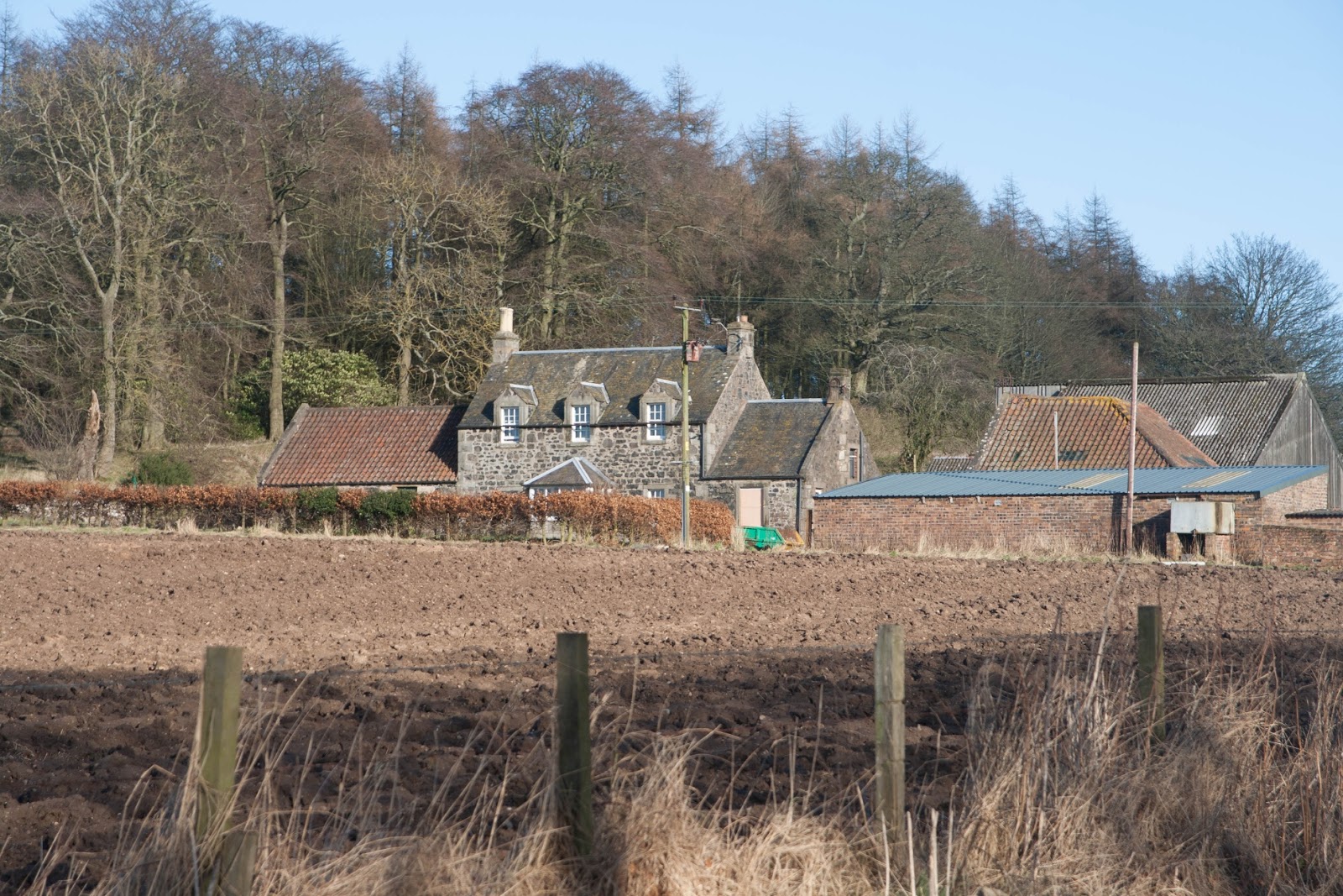
I would soon be at Kilbrachmont, about which I have talked
before.
 |
| Approaching Kilbrackmont. NO4705 |
 |
| Kilbrackmont Farm. NO4705 |
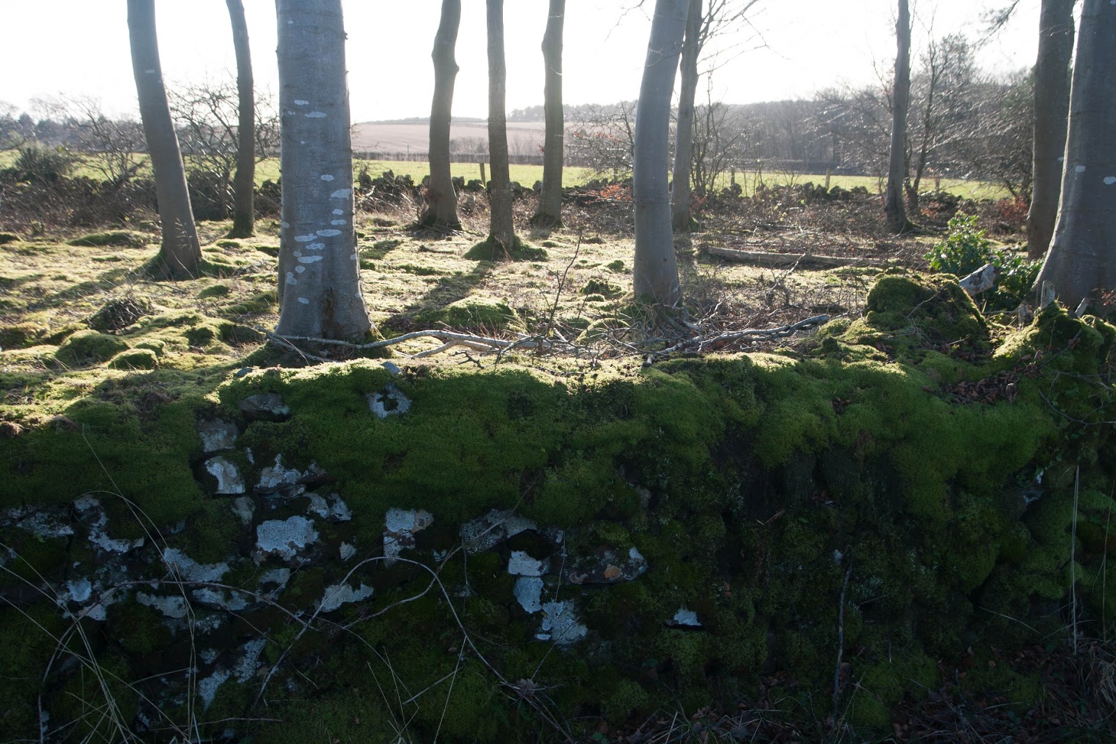
I loved the ancient 'foggit' (moss-covered) wall I passed walking down Kilbrackmont drive.
 |
| Foggit wall near Kilbrackmont. NO4706 |
Reaching the B941 I turned left and then right past a lodge house. I wasn't sure if I would be trespassing or not to walk past the lodge house, so opted for a slightly long way round, hoping the dotted line shown on my map would, in fact, turn out to be an exiting footpath. It was. Phew! It meant being in NO4605 slightly longer, although I ended up photographing the same thing I'd have photographed if I'd taken the shorter route, a bridge over a burn.
 |
| Bridge in Mill Wood near Lathallan Mill. NO4605 |
I passed a sign for Lathallan Mine Water Treatment Works and decided to investigate. Perhaps there would be another way out instead of having to walk along the road. Although it was a very minor road (white on the map) a few cars passed me whilst walking and, as I've mentioned umpteen times, I do prefer to be solitary if I've chosen to walk that way.
 |
| Lathallan Mine Water Treatment Works. NO4606 |
It was a pleasant enough walk, although there were plenty of off-putting signs about the danger of deep water, but there was no way out at the end of it, so I turned round and walked up the road instead. I passed another ruin, which is not mentioned on the new website I have found -
Pastmap. I am assuming it is part of Lathallan Home Farm.
 |
| Building near Lathallan Home Farm. NO4606 |
At a T-junction I turned right, away from Lathallan Home Farm. I was on my own homeward stretch now. I was back to a dismantled railway - the East Fife Central (|or mineral) Railway. Station House was on my left.
 |
| Station House, Largoward. NO4606 |
 |
| Former East Fife Central mineral railway at Largoward. NO4606 |
The East Fife Central Railway was a mineral railway line that ran from near Leven to Lochty. It was intended to develop extensive coal measures in the area and opened in 1898. Sadly, the line was loss-making from the outset and closed in 1964.
 |
| Former railway bridge at Largoward. NO4606 |
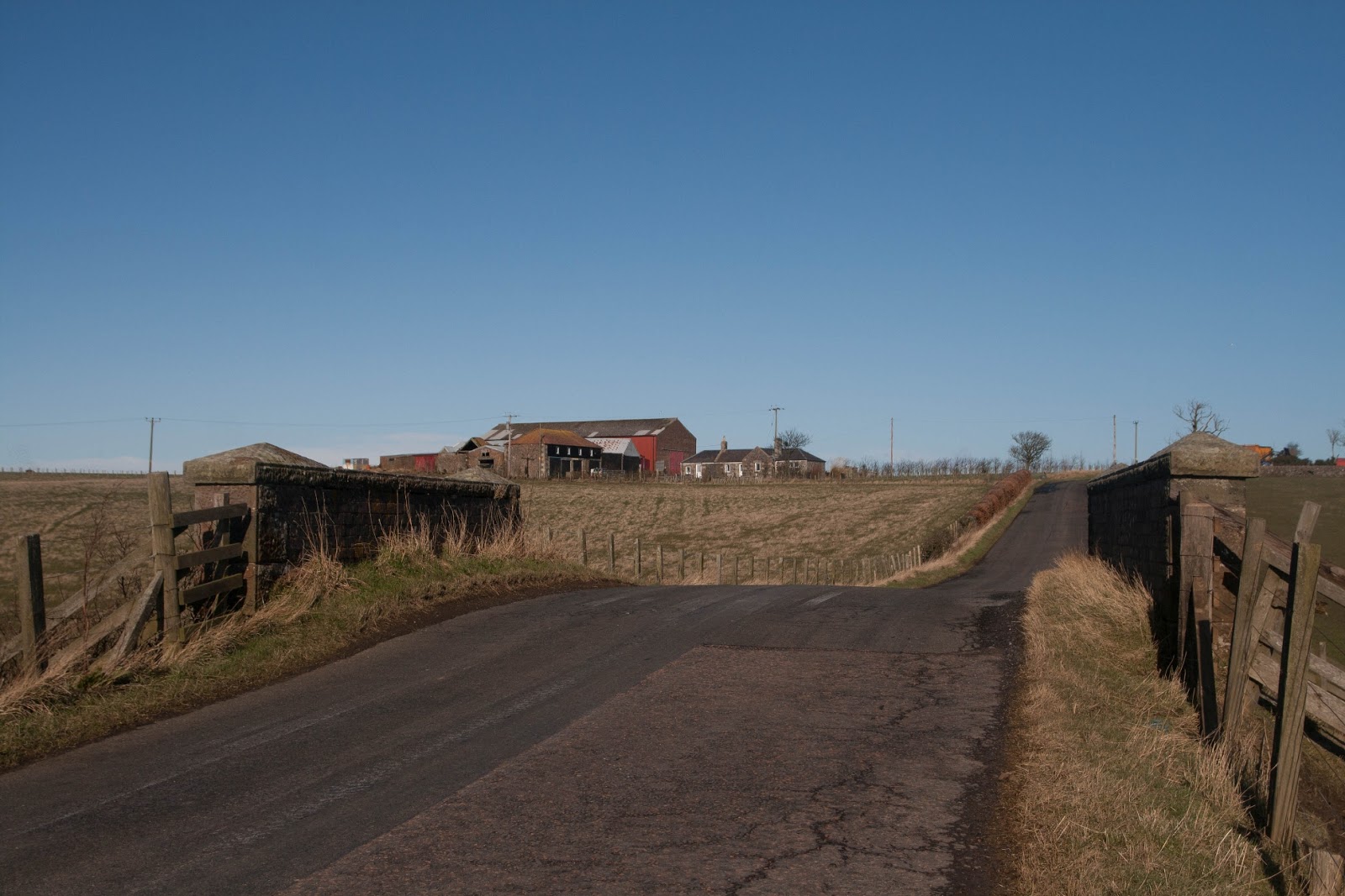
With that, I had photographed my final gridsquare of the day. I approached my final T-junction and wandered wearily back to the car.
 |
| Approaching Largoward. NO4607 |
Number of new gridsquares: 13 (Plus four from a previous walk)
Number of miles walked: 12.8
Walk worth repeating: Without its gratuitous bits and diversions, yes, especially to include Carnbee
Highlights: Kellie Law, lovely old tracks