I've entitled this 'Of folly and follies' because some might say it was folly for me to venture out alone on the day of Storm Dennis. Truth is, I cherish my free time so much, I am loathe to relinquish it to the sofa, so, knowing that there was only myself that could possibly rant and rave about getting cold and wet and hit on the head by a falling branch, I set off from Beveridge Park car park with enough layers to keep me warm in Antarctica. Oh, and the other type of folly you'll see soon enough . . .
 |
| Beveridge Park, Kirkcaldy. NT2790 |
Knowing that the only people I was likely to see today were dog walkers in Beveridge Park, I hastened through this deserted land, spying only a handful of hardy souls and shivering dogs.
I'm not convinced I've admitted to another penchant of mine which I have recently allowed myself to indulge in - that of spying benchmarks. Yes, I knew you'd be excited. On these solo excursions I am not content enough with photographing every gridsquare and making an alphabetical list of all the birds and animals I see (soon to be added - flora!); I also have to plot all the benchmarks from the Ordnance Survey's excellent
database and go and hunt these out. Most of them have either been removed or covered over and I do limit the length of time I hunt for them because, quite frankly, it's a little embarrassing staring for too long at a wall. People begin to think you've gone crazy. Anyway, I found a total of 10 out of about 20 today, so that's pretty good going.
The first two were along Balwearie Road and, at the risk of boring you completely, I'll include just one photo.
 |
| Balwearie Road benchmark. NT2790 |
I recognised the road from my drives to Balwearie High School on Friday evenings for badminton. I had always wondered where the road led after I turned left to the school and I was about to find out . . the golf club, and onwards to Balwearie.
The fields were very flooded here and I paused to take a photo of a statue-like Grey Heron which took flight upon the snappy arrival of three terriers - the owner of which was the last person I was to see until I arrived back in Kirkcaldy several hours later.
 |
| Flooded fields west of Beveridge Park. NT2690 |
 |
| Grey Heron |
I trudged uphill, getting warmer and warmer.
 |
| Track to Balwearie. NT2690 |
 |
| Track to Balwearie. NT2590 |
It would be interesting to see where the footpath leads that continues westwards at Balwearie (where there is also marked a ruined Castle and a benchmark), but my route today headed north just before Balwearie.
 |
| Balwearie. NT2590 |
 |
| Balwearie. NT2590 |
I forgot that a taxi passed me along this road, stopping at Balwearie, turning round and coming back again. I also forgot that I did pass another soul - a man out for a walk with his dog. I very rarely see anyone out for a walk who hasn't got a dog. I didn't see any evidence of a ruined castle, but there was a lot of evidence of the recent heavy rainfall.
At Boglily Braes, I paused to admire some lovely rootworks.
 |
| Tree roots, Boglily Braes. NT2590 |
 |
| Boglily Braes. NT2590 |
I feel sure this curvy little road will look delightful in spring and summer. perhaps adorned with Bluebells. I must return to investigate. That's three walks I've got to do that for so far!
But would I ever get out of NT2590?!
 |
| Raith House (NT2591) from NT2590 |
I emerged at the B925 near the Buffalo Farm (Boglily Farm), opposite which are what probably used to be the gateposts of the driveway to Balwearie Castle, adorned with a benchmark!
 |
| Former entrance to Balwearie Castle (benchmark is on left-hand post) NT2591 |
Just west of the Buffalo Farm I turned right on an unsignposted footpath which led to a padlocked gate. Undeterred I followed the field round, glad of Memory Map to guide me (how did I manage pre-Memory Map?) Stepping over a broken chicken wire fence, I arrived at a minor road and bridge. This was Croupie Craigs Bridge and it spans the Dronachy Burn which feeds into Raith Lake.
 |
| Croupie Craigs Bridge. NT2591 |
It didn't take me long to find the delightful rivet benchmark on this bridge. It immediately became my favourite Fife benchmark; I think it is my first ever Fife rivet benchmark.
 |
| Rivet benchmark, Croupie Craigs Bridge. NT2591 |
 |
| Waterfall and Snowdrops at Croupie Craigs Bridge. NT2591 |
I nearly missed this delightful scene because I walked over the bridge and was going to go to find somewhere to sit with my cup of tea, but was drawn down to the water where this scene met my eyes. It was an obvious place to partake of some refreshment. I sat with the sound of the waterfall and the silent unassuming Snowdrops, munching my packet of crisps, thinking life does not get much better than this.
The next landmark was Lady's Bridge where there was also a benchmark, but, despite a prolonged search, I could not find it.
 |
| Lady's Bridge and Datiefauld Plantation. NT2491 |
At a small pond further on, I spied Little Grebe, Mute Swan and Mallard and added them to my alphabetised list.
 |
| Pond near Cotton Bank. NT2491 |
To the north-west I could see what looked like a ruined church, with another one to the north, but, despite scouring the map, I could not see what these buildings were. I worked out I would be heading in the direction of the one to the north-west so would get a closer look and be able to see exactly where I was on the map.
I bypassed NT2492 as I would be re-entering it later on, and headed straight for the ruin I could see ahead of me. Surely it was a church?
 |
| Lambswell Folly. NT2392 |
I later discovered it was
not a church, but one of three early 19th Century Raith Follies. The other two are Balwearie Tower and Torbain Tower. I haven't been able to find out anything else about these extraordinary buildings.
This was proving to be a very interesting walk and thankfully the weather was not only holding, but was actually sunny at times.
I continued to Bankhead of Raith, finding another old benchmark beneath a telegraph pole which I felt sure no-one had seen since it was first cut however many decades ago.
 |
| Benchmark near Bankhead of Raith. NT2392 |
I spent some time exploring Bankhead of Raith ruin, one because there was supposed to be a benchmark there and two because it was derelict so no-one was going to accost me. What a glorious place to live with views to the Lomond Hills to the north-west and the Forth to the east. I did not find the benchmark though.
 |
| Bankhead of Raith. NT2392 |
The cottages next door were inhabited but I did not see anyone, only wheelie bins at the end of the drive, which I photographed as it was a new square and one I was only nipping in and out of .
 |
| Bankhead of Raith junction. NT2393 |
Due to lots of traffic, it was not a pleasant walk down the road to Torbain, where I could see the next folly (although I did not know that's what it was at the time). I stepped aside to let a car past and it splattered me and my camera as it sped through a puddle. I shouted after it to let off steam as it disappeared round the corner.
 |
| Torbain Tower. NT2492 |
 |
| Torbain Farm. NT2492 |
The tower is part of another derelict farm. There was a huge pile of rubbish in one of the barns and an interesting chimney. I didn't sound my horn for attention despite the invitation to do so; I'd rather no-one know I'd been!
A turn off onto a long, straight path led me to the western edge of Kirkcaldy. Was this Chapel, Newliston or Templehall? I wasn't sure. I was sure, however, that the best part of my walk was behind me and I wondered if I should have done it in reverse to get this bit over and done with first. But then I had thought it was going to rain in the afternoon, which meant I would have risked walking through the most attractive part in the rain.
 |
| Straight path to Kirkcaldy. NT2492 |
 |
| Junction at Newliston, Kirkcaldy. NT2593 |
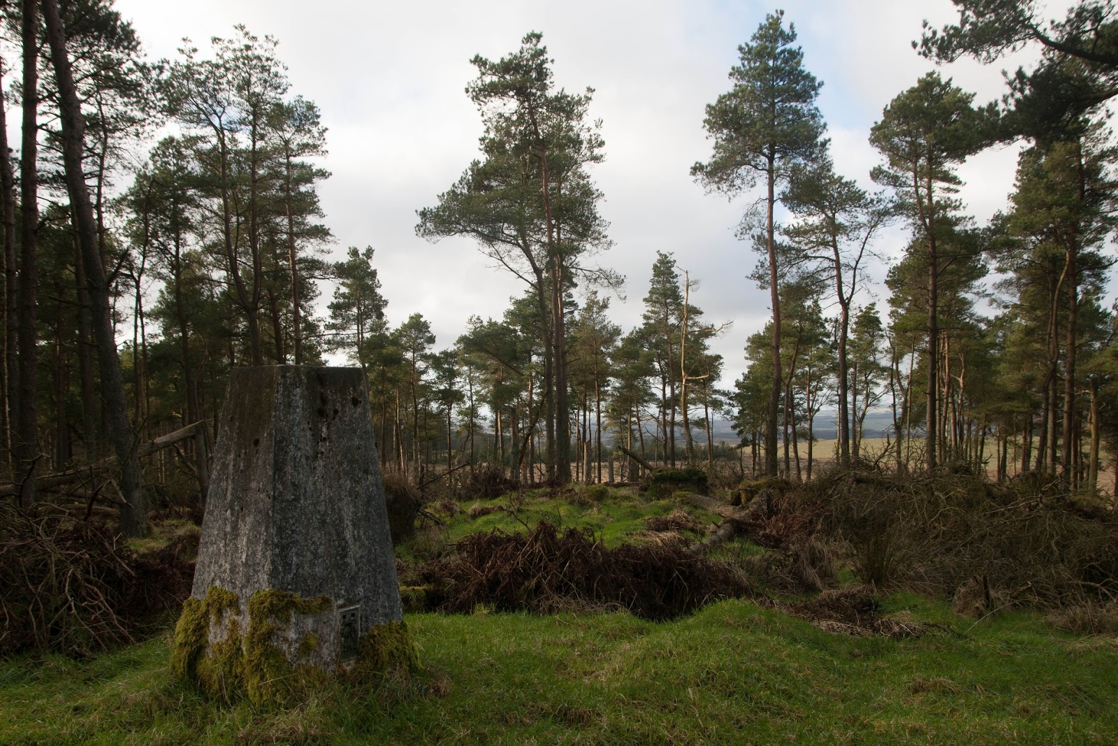
My next mission was to find the trigpoint at Kirkcaldy's highest point, Bogie Mains. This did not prove difficult to do.
 |
| Bogie Mains trigpoint, Kirkcaldy (122 M). NT2593 |
I now wended my way through Potmeal Plantation, skirting some high(ish) rise flats.
 |
| Potmeal Plantation, Kirkcaldy. NT2592 |
This now seems to be known as Rabbit Braes Community Park and is adorned with various wooden sculptures, presumably depicting some of the creatures you can expect to see here, except maybe not wolves!
 |
| Rabbit Braes Community Park. NT2592 |
I was getting in need of somewhere to sit and eat my lunch and that's what made me half wish I'd done the walk the other way round. It was getting towards lunch time and I was now in a built up area with teenagers wandering round, so not conducive to a relaxing picnic.
 |
| Longbraes Plantation, Kirkcaldy. NT2692 |
Looking at the map now, I can see an alternative way back to the car park and this is another reason to reattempt this walk. It would negate the need to return via the town itself, making it a more pleasant route of approximately the same length.
As it was, I found a tree trunk to sit on, out of sight of teenagers or anyone else and ate my lunch.
Then I continued through Longbraes Plantation till it met the A910, where I crossed the road and joined another footpath heading south, past a small birdless pond (other than Mallard).
 |
| Pond near Raith Lake. NT2691 |
I followed this path through a housing estate to its end at a roundabout I was very familiar with from my badminton travelling. I photographed my final gridsquare and walked back to the car. I had stayed dry all day and had a thoroughly enjoyable walk. If I hadn't known Storm Dennis was hitting the rest of the country, I certainly wouldn't have known as a result of this walk!
 |
| Beveridge Park with lion statues. NT2791 |
Number of new gridsquares: 13
Number of miles walked: 9.5
Number of follies seen: 2
Number of trigpoints bagged: 1
Number of benchmarks spotted: 9
Walk worth repeating: yes, with alterations to avoid walking through Kirkcaldy. Revisit Boglily Braes in spring or summer, look for Balwearie Castle and Raith Tower. Maybe extend to burial ground (and another trig) north of A92.
Highlights: Croupie Craigs Bridge and waterfall, Bankhead of Raith farmhouse with view, Lambswell and Torbain follies.